
PERRY COUNTY
“Up and Down and All Around”
20 November 2021
On the road again.
Willie went through my head as we entered Perry County, southbound, along Ohio Route 13. It had been 21 months and 18 days since we’d last traversed the back roads of the state and I was going into withdrawal. An Ohio travel-holic can go only so long without seeing a covered bridge or reading an historical marker before the sweats begin, but there’s not much one can do when a worldwide pandemic hits.
The pleasure of wandering our state quickly returned when, south of Thornville, Michele spotted out her window a half dozen deer picking over stubbly autumn fields.
Shortly after the road curved to the east, we slowed and turned south onto Township Road 36. The pavement was replaced by gravel and our speed decreased even more. About a mile later, after navigating a couple of 90 degree turns on the narrow lane, we came upon our first goal: a large round barn. Measuring and imposing 68 feet in diameter and 50 feet tall, it was a bit startling to come upon. I’m not sure why a common farm building constructed in a common geometric shape should cause such amazement, but it does. I guess it’s the uncommon pairing that astounds.
A round barn was first built at this location in 1917. When a fire destroyed it in 1932, it was rebuilt. After a couple oohs and aahs and a quick picture, we continued south, happy to see pavement again on Rush Creek Road. It led us back to Route 13, which in turn led us into the village of Somerset.

A few years before Ohio became a state, a rough road was blazed through the territory connecting Wheeling, [later West] Virginia and Maysville, Kentucky. It was named Zane’s Trace in honor of Col. Ebenezer Zane, the man who oversaw its construction. The Ohio towns of Zanesville and Lancaster were laid out at strategic river crossings along this path. In 1810, a decade after those two communities were platted, Somerset was established halfway between the two. Early settlers from Somerset, Pennsylvania brought their former home’s name with them.
Perry County was created in 1817 from portions carved out of Fairfield, Muskingum, and Washington Counties. Somerset became the county seat. Its public square, the focal point of early business and government, became home to a brick courthouse in 1829. The structure was nearly square in shape and topped with a central tower. In the 1850s, intra-county bickering resulting in the county seat being batted back and forth between Somerset and New Lexington. The Ohio Supreme Court stepped in and settled the matter in the latter’s favor. The former county courthouse then became Somerset’s village hall and continues to house local government offices.
In 1905, the square acquired a centerpiece when the State of Ohio donated a statue of General Phil Sheridan to the village. Sheridan grew up in Somerset before heading off to the United States Military Academy and onto fame in the Civil War. At the age of 33, he attained the rank of Major General in the United States Army. His cavalry pursuit of Confederate General Robert E. Lee in the Appomattox Campaign of 1865 was instrumental in forcing Lee to surrender. Sheridan later fought in the Indian Wars of the Great Plains and, as a soldier and private citizen, played a part in the development and protection of Yellowstone National Park.

Sometimes known as “Little Phil,” Sheridan stood only 5 feet, 5 inches tall (That’s two inches shorter than Iggy Pop!), a fact not discernable from his statue. Sculptor Carl Heber portrays the general waving his hat in the air and riding high atop a rearing horse.
The traffic circle that moves around the monument does so in a predictable clockwise manner, but doesn’t follow the normal roundabout protocol where the vehicle on the left has the right of way. In Somerset, as busy traffic from Ohio Route 13 and U.S. Route 22 flows in and out of the square, signs instruct drivers to “yield to traffic on the right.” I pulled into a parking space on the square to get my bearings. That was a mistake. From the center, traffic seems to come from all directions at once. My head had to swivel like a bobblehead to see all 360 degrees at once. My nerves jangled as I was eventually successful in safely backing out into traffic.
My Perry County foreplanning was for naught when we found our first choice for breakfast was no longer in business, so we veered off onto West Main Street and discovered Sophie’s Tea Room instead. The restaurant opened at the end of 2014 and earned a “New Business of the Year” award from the Perry County Chamber of Commerce. The sign on its front door notified diners, “If vaccinated, you can forget about a mask at your discretion.” We were vaccinated, but still chose to wear masks during our 15-minute wait for a table.
Once seated, we discovered the scones in the display case were quickly disappearing, so we ordered two right away. I asked for orange cranberry and Michele got cherry almond. Both were delicious! We followed those up with a “small breakfast” (2 scrambled eggs, 2 pieces of bacon, 2 pieces of toast) for myself and “Sophie’s Burrito” for Michele.
After breakfast, we drove northeast out of town, following State Route 668 on its winding course past alternating farms and tree lots. We turned left at Gower Road and a mile later, came upon a 58-foot long covered bridge over Painter Creek. Since its construction in 1883, it’s been known variously as the old Parks Bridge, the South Bridge, and the Gower Road Covered Bridge.
A mile up the road, we parked in the gravel lot at Hopewell United Methodist Church so I could walk down Cooperriders Road to a second covered bridge, a virtual twin of the first. It is slightly older (1874) and shorter (55 feet long), but painted in the same red, white, and blue colors that were sanctioned by Perry County officials in 1976 in honor of the country’s Bicentennial.
We proceeded west on Cooperriders Road, but had to slow down when we came upon three deer ambling across the road in front of us. After they passed, we proceeded cautiously in case they were just an advance guard of a larger ruminant army, but we didn’t detect any others.
At the intersection with State Route 757, we turned right and drove a half mile and a couple millennia into the past to visit the Glenford Fort Preserve. The preserve contains an ancient Adena-Hopewell hilltop enclosure that’s been dated to about 270 BCE. It is believed to have been used for ceremonial purposes.
The “fort” was on private land until recently when a group consisting of the Perry Soil & Water Conservation District, the Perry County Historical and Cultural Arts Society, Arc of Appalachia, and the Heartland Conservancy District raised funds to purchase it in order to preserve its history. A permit is required to visit the site, but it’s a pretty simple process of contacting the Perry SWCD, filling out an application, and signing an indemnity release form. The latter ensures that should you do anything stupid while on the grounds and injure yourself, you’re on your own, buster, and can’t sue any of the owning organizations. Fair enough.
A chain across the lane meant we had to work off our breakfast the old-fashioned way by walking up the road to the enclosure. We passed what looked to be a house, but was marked on our map as an “Education/Nature Center.” It was closed. A series of short trails led us up to the Glenford Fort Gateway, a passageway through a stone wall.
As we reached the hilltop, the forest cleared to reveal a large soybean field. In its center was the “Stone Mound,” so called for a stone ring that once encircled the mound. Some imagination was useful since it resembled more a scrub-covered hill. It is 110 feet in diameter and 15 feet high. I followed animal paths through the soybeans and began to circumnavigate the mound when my loud human presence flushed out a deer. It quickly bounded away. I’m not sure which of us was more startled.
On our return hike to the car, Michele spotted a woolly bear caterpillar in the road. She picked it up – as she will with any woolly bear she encounters – and discovered it had a wide brown stripe. According to folklore, that signifies we’re in for a mild winter.
Back in the car, we took State Route 757 south through Somerset and continued from there on State Route 668 to Junction City. Just beyond the village’s eastern boundary, we turned on County Route 94A where we found another round barn. It was constructed in 1908 on what is still called the old Mott Thomas Farm even though the property is now owned by John McGaughey and his family. A collection of rolled bales of hay near the road provided a picturesque foreground for my photograph of the russet-roofed barn.
The day of our county trip coincided with the Ohio State-Michigan State football game, so soon after the noon kickoff, we turned on the radio and allowed the play-by-play to provide a soundtrack for our driving. The hits just kept coming as the Buckeyes ran over the Spartans in a nonstop series of first half touchdowns.
From Junction City, we continued south on State Route 668. It has to be one of the hilliest roads I’ve ever driven. Its deep plunges and dizzying ascents resembled a roller coaster…or the daily number of Ohio COVID cases.
Near the southern boundary of Jackson Township, we pulled into the parking lot for Friendship Church and its accompanying cemetery. The purpose for my stop was more than just a pleasurable stroll through a countryside graveyard. I have ancestors buried there; my great grandfather, Daniel Ricketts, and his parents, Ignatius and Margaret.
Ignatius and Margaret, both born in the 1780s, were married in Maryland in 1805. They had three children and lived for a time in Randolph County [West] Virginia, where Daniel was born in 1812. They moved to Ohio in the fall of 1816 – a mere 13 years after statehood -- and settled in Perry County two years later. Ignatius was a farmer. He died in 1855, and Margaret a decade later.
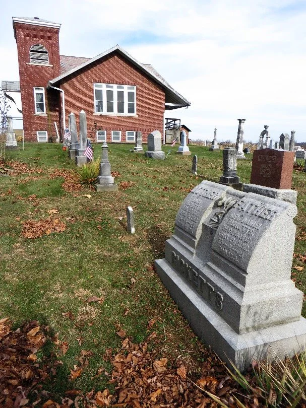
Daniel followed in his father’s agricultural footsteps, amassing nearly 900 acres of land. During that time, he fathered sixteen children with his first wife. He also became an ordained Methodist minister and spent much of his life as a circuit riding preacher. He cut back his traveling around 1882 to care for his ailing wife. He also brought a young girl into the household to help. Six months after his wife died in 1888, Daniel married the nursemaid, Maggie Finley, who was my great grandmother. Daniel was 75 years old and Maggie was 20.
Ew!
I mean, it’s not as though Daniel owned slaves or bludgeoned a neighbor to death after gambling away the family cow, but still, ew!
I stood for a while next to the graves of my forebears contemplating their lives and wondering what, if any, family traits had passed through the generations to me. Do I have any latent desires to till the land? Is this why “Harold and Maude” is one of my favorite movies?
Before I could come to any substantial conclusions, we were back on the road, driving east across a ridge on Marietta Road. A turn south on State Route 93 led us into what was once the heart of the state’s coal country. Around the turn of the last century, Perry County ranked as the largest coal-producing county in the state. Its four southern townships were part of the Hocking Valley coal field, where underground seams averaged five to 13 and a half feet thick.
One of the largest coal towns was Shawnee; attaining a population of 4,000 during its boom years. Unfortunately, booms are often followed by busts and many of the coal towns just disappeared. Shawnee wasn’t one of them, but it’s a shadow of its former self. With a current population of around 700, it maintains a pride in its history and a determination to survive. The town was built on the side of a hill, making its Main Street easily visible from the State Route. It claims to feature one of the best standing examples of boom town architecture in the eastern United States. One of the first businesses a visitor notices when approaching Main Street is the Black Diamond Tavern which is housed in an 1877 building. In the pocket park next door is a statue of a kneeling coal miner, commemorating the town’s history. Sculpted by Ohio artist Alan Cottrill, it was dedicated in 2011.
A couple miles south from Shawnee is New Straitsville, another of the “Little Cities of Black Diamonds,” a name given to the Appalachian communities that were tied to coal mining. Opting for a different take on its history, New Straitsville commemorates its heritage each Memorial Day Weekend with an annual Moonshine Festival.
Just north of New Straitsville, at the trailhead of a path leading into a section of the Wayne National Forest, sits an historical marker that tells the story of the “World’s Greatest Mine Fire.” For many years, miners didn’t have an organized voice when disputes erupted over working conditions. Tensions often ran high and violence was common. During the Hocking Valley Coal Strike of 1884-1885, mine owners brought in “scab” workers which further enraged miners. In retaliation, a group of unknown men pushed burning mine cars into six of the mines setting the underground coal on fire. Despite efforts to put the fire out, it continued to burn…and burn…and burn…and still burns today. Over the years, the burning mines occasionally caused roads to collapse and flames to shoot out from the ground. I don’t think it had anything to do with the mine fire, but a Wayne National Forest sign warned us that the day’s risk for fire was moderate.
We changed directions and drove east along State Route 155 across the southern portion of the county. East of the communities of Hemlock and Corning, the elevation became more pronounced as we motored up Waterworks Road to Irish Ridge Road. On what appeared to be a rarely used roadway, I found the trailhead for the Monroe Outlook trail. It’s only a quarter mile long, so it didn’t give me much of a workout, but a series of interpretive plaques provided information about the area’s flora and fauna, and the trail led to a pleasant hilltop outlook.
We returned to Corning and changed directions again, turning north onto State Route 13. We passed by more coal town ghosts: Rendville and Moxahala. At Moores Junction, we picked up State Route 93. At the northern edge of Bearfield Township, we pulled off the road to read another historical marker, this one commemorating the area as “Ohio’s Icebox.”
On February 10, 1899, during a severe cold spell that affected most of the United States, the U.S. Weather Bureau Station in Milligan, Ohio reported a temperature of 39 degrees below zero, the lowest ever recorded in Ohio. According to the historical marker, “Milligan's location in the flat valley of the Moxahala Creek made it susceptible to cold air masses drained from surrounding elevations.” The hamlet of Milligan no longer exists, having been absorbed into nearby McLuney, but the record remains. The temperatures on the day of our visit were in the 40’s, more than 80 degrees warmer than that frigid record. That didn’t stop me from wrapping myself in a winter coat, hat, gloves, and scarf for a photo op.

39 Below Zero! In 1899.
We backtracked to Moores Junction and followed State Route 93 into the county seat of New Lexington. It’s a little known fact that an excess of historical marker reading can create an extreme thirst for adult beverages. We found Trotter’s Café and Sports Bar on North Main Street to be the ideal spot to wet our whistle. As hoped for, it also provided television screens tuned to the Buckeyes football game.
The establishment has two separate sections, a restaurant and a bar. We bellied up to the latter where there were only three to six other people at any time during our stay. We enjoyed pints of Terrapin’s High & Hazy IPA while watching most of the second half of a game that found OSU routing the Spartans 56-7.
When it came time to settle up our tab, I looked at the total and assumed there’d been a mistake. Our beers were only $3 each! We’d easily be charged double that at just about any bar in Columbus. When I voiced my surprise to the bartender, she responded, “We get that a lot.” She explained why they have to keep their prices low: “We’re a small town.”
A few doors south of Trotter’s is the Perry County Courthouse. It was constructed in 1887, 30 years after New Lexington wrestled away from Somerset the right to be the county seat. The stone structure was designed by Columbus architect Joseph W. Yost. Its Richardsonian Romanesque architectural style originated with 19th century architect Henry Hobson Richardson who incorporated 11th and 12th century southern French, Spanish, and Italian Romanesque characteristics.
Across Main Street from the courthouse is Doobie Park, whose name BEGS for being the local hangout for potheads. The small corner greenspace contains a statue of Janarius Aloysius MacGahan. Yeah, I’d never heard of him either, but he’s known as the “Liberator of Bulgaria.” He was born in New Lexington in 1844, but gained fame half a world away as a war correspondent. His graphic reporting of the massacre of Bulgarians at the hands of Ottoman Turks in 1876 caused such an international hullaballoo that Great Britain refused to support Turkey in the Russo-Turkish War of 1877–78. The war led to Bulgaria gaining independence from the Ottoman Empire.
My research was unsuccessful in determining how much weed MacGahan may have smoked in his life, but you’ve got to think that if he was as good an investigative reporter as they say he was, he must have been checking out the Istanbul hash market. It certainly would have eased his pain from the typhoid fever that caused his death there in 1878.

Before leaving New Lexington, in our effort to check out the county’s round, or nearly-round structures, we drove down South Main Street where we found an octagon house. The two-story structure was built in 1850 by local resident David C. Fowler. Family lore says that Fowler was returning from a bull-buying excursion in Baltimore, Maryland when he stayed for a night in an octagon log building. He was so taken with the oddity that he sketched it in his notepad and recreated it at home in brick.
From the present county seat to the former, we traveled up Route 13 for our return to Somerset. The afternoon was waning and our stomachs were demanding sustenance. If one is interested in history, then the recommended restaurant is the Clay Haus. The restaurant only dates to 1978, but the renovated brick home in which it is housed was constructed in the early 1800s. It turns out the food is good, too!
The menu offers an eclectic variety ranging from sauerbraten to beef liver and onions. I opted for grilled chicken on a bed of rice and covered with orange sauce (i.e. Chicken a L’Orange) while Michele went with a Nashville hot chicken sandwich. Both were delicious, as were our desserts of Oreo cheesecake and German chocolate cake.
We recognized one of the waitstaff as the woman who seated us at Sophie’s Tea Room earlier in the day. She noticed us, too, and came over to our table to offer a friendly greeting. We were obviously not locals, so we explained our trip and gave a quick summary of our entertaining day in her county. Who doesn’t like to hear satisfied reviews from strangers visiting your home town and environs?
By the time we left the restaurant and returned to our car, the sun had set and a deep darkness had descended. Without any illumination beyond our headlights, we departed the county under a very, very coal-black sky.
Time spent in the county: 8 hours, 38 minutes.
Miles driven in the county: 113
Click here for a link to previous Ohio County Trippin’ Stories from Nick Taggart